About Somalia Municipality Risk Dashboard
The Somalia Municipality Risk Dashboard is an interactive web-based Geographic Information System (GIS) built to support municipal risk management, land administration, and spatial planning across Somalia. It brings together land parcels, administrative boundaries, buildings, roads, landmarks, and other geospatial layers in one platform to enable visualization, analysis, and evidence-based urban decision-making.
Purpose
The Somalia Municipality Risk Dashboard is designed to strengthen municipal risk management by giving users access to reliable geospatial information for planning and decision-making. It supports government institutions, planners, surveyors, researchers, and development partners with practical tools to map hazards and exposure, analyze urban risk patterns, monitor land use dynamics, and guide resilient, evidence-based development across Somalia.
Key Features
- Interactive land parcel visualization.
- Administrative boundary mapping.
- Buildings, roads, and landmark datasets.
- Hazard and exposure mapping
- Dynamic map legend and information panels.
- Scalable and modern web-based GIS dashboard.
Technology Stack
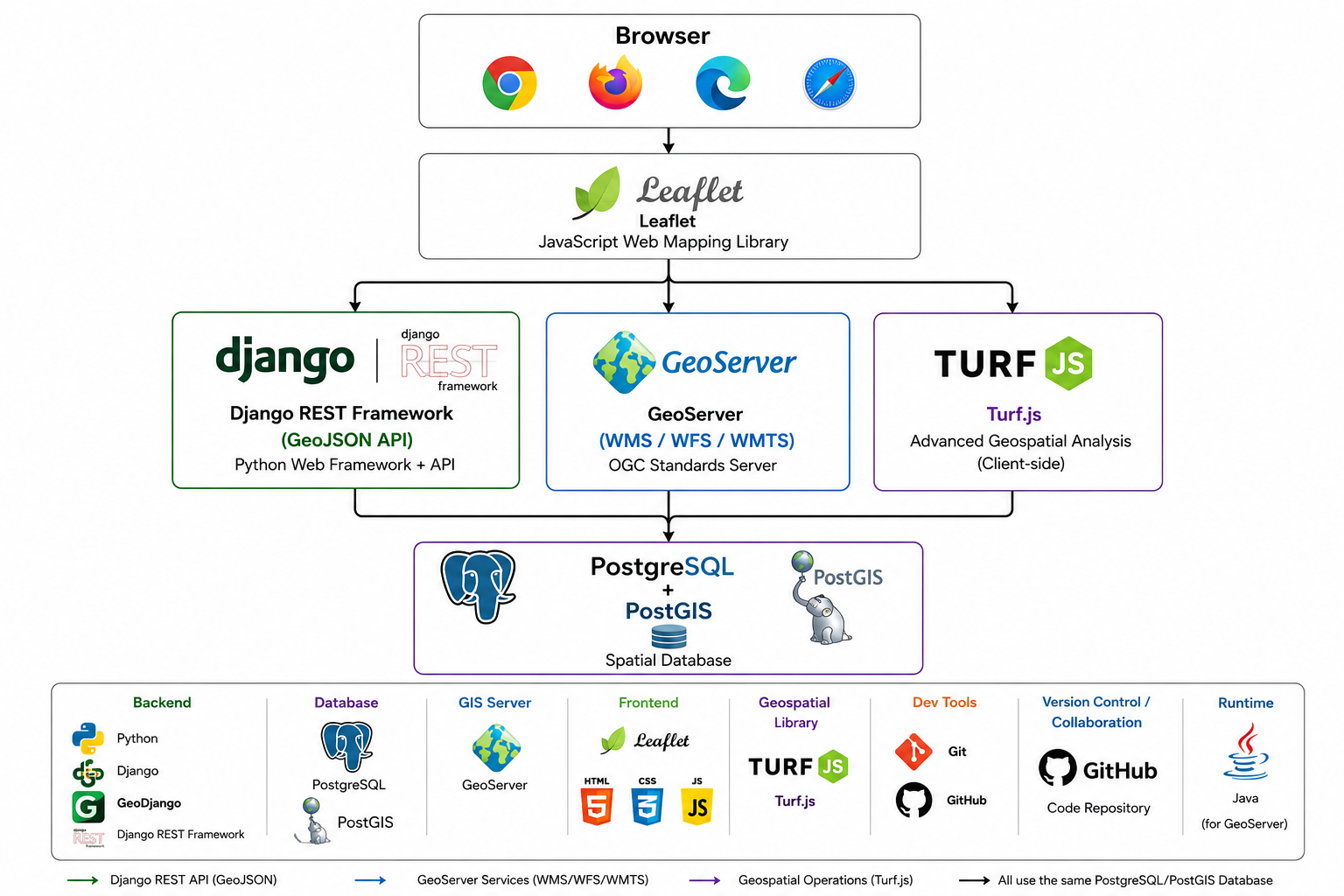
The Somalia Municipality Risk Dashboard is built using a modern web technology stack which is opensource and widely used in the geospatial community.
The goal is to provide an open, transparent, and accessible platform for managing and analyzing geospatial data related to municipal risk management in Somalia.
The technology stack includes:
- Django (GeoDjango)
- Django REST Framework
- PostgreSQL & PostGIS
- Leaflet.js
- Bootstrap 5
- Chart.js
- DataTables
Resources/Downloads
Browse and download technical reports, spatial datasets and policy briefs produced under the Somalia Municipal Risk Monitoring programme. Final document content will be added as publications are released.
- Somalia Urban Resilience Project Phase II (SURP II) - Nagaad Project (P170922): Project Overview
- Somalia Contingent Emergency Response Project (CERP) (P173315): Project Overview
- [coming soon] Spatial data layers
Developer
Abdillahi Omar
GIS Developer & Geospatial Analyst
GFDRR, World Bank Group
Email:
[email protected]
Supervisors
Benjamin Joseph Kushner
World Bank Somalia Senior Disaster Risk Management Specialist
Email:
[email protected]
Pierre Chrzanowski
World Bank GFDRR Disaster Risk Management Specialist
Email:
[email protected]
Copyright
© 2026 World Bank Group · Somalia Country Office · Global Facility for Disaster Reduction and Recovery (GFDRR)